Have You Done Your Homework?
Although the bass season is already underway for some of us, it’s never too late to do some advance thinking, in preparation for those hoped-for bass trips this year. If you generally do snap sessions, or just go bassing when on holiday or while working away etc, then you only need to do advance thinking on the run-up to each trip, but if you like to have some sort of systematic approach, it can help if you can do some early thinking and early checking-out of venues and their tides. For this you need to get the diary out, get your hands on some maps and a few other things, and get your thinking cap on.
Firstly choose a stretch of coast you wish to concentrate on and decide on your practical limits for the coming season. These might be your own physical limits (how far you can walk), or limits to do with the type of areas you like to fish (estuaries / open coast) or from a launch site when boat/kayak fishing. Then look up your chosen area (or areas) and get acquainted with the terrain, the means of access (parking, footpaths etc), using whatever information source you can muster such as: Google Earth, Admiralty charts, Ordinance Survey maps, regional angling guide books (preferably no more than say, 20 years old) and perhaps yachting pilotage books (these, if borrowed from libraries, can be quite out of date, but they do give lots of general information about currents, tides, boating channels, bouys, markers and the like).
For the stretch of coast you have set yourself, study the sources of information and write a shortlist of the places that a bass might hunt in, or around, such as:
- Natural rocky ground (e.g. rock ledges, rock ‘fingers’ and rocky channels)
- Stony ground (e.g. storm beaches having shingle channel(s) that could be cast into)
- Estuary features (e.g. bait beds, old structures or wreckage partly underwater, channels that fill up on the flood)
- Backwaters and creeks that flow to the sea
- Rocky areas at the ends of beaches
- Man-made sea defences (e.g. boulder outcrops, breakwaters)
- Pleasure piers on stilts
- Solid piers
- Bait beds
- Breakwaters
- Harbour arms
- Headlands
- Coves
Most of us use Google Earth for this type of research and in many cases the most recent set of images are the most accurate and detailed. However, they are just a snapshot from space, at any given time, so sometimes clouds can obscure the aerial view or the sun might not be shining to give the best image. Another, more important variable, is the state of the tide when the Google Earth image was taken.
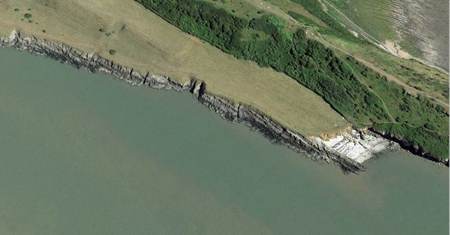
This is the most up-to-date image (from 2020) of a rock mark, where a headland appears to fall into deep water from the steep rocky shoreline, so it may not be ideal for bass fishing, as no bass-enticing structure is visible.
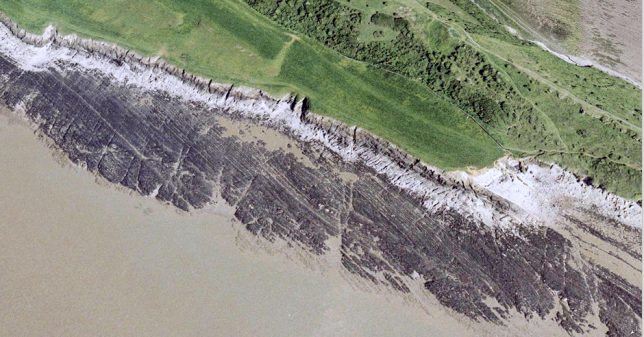
But by scrolling back to the image taken in 2005, we see that this shot was obviously taken at low tide and now we can see that there is an extensive area of ledges and gullies, well within casting range and just the kind of place that bass like to forage for crabs, prawns and small rockfish as the tide begins to cover the reef. This could be a new mark worth exploring!
Once you’ve sussed out a likely bit of shoreline, go and visit the area on a spring tide at low water, and at high water, taking notes and photos. This is also a good time to check out the parking and access points. Get to know the possible ‘bassy’ features within casting range, and the type of bottom. Also note where these bassy features are with regard to visible markers such as tall trees, towers, paths etc., so that you could conceivably cast to a particular feature when the water is in, or when it’s dark, or both. Make a mental note any other visual clues such as high water staining on cliffs and harbour walls, to get an idea of the water depth at high tide. Make a note of where large rockpools are, in relation to fixed objects such as a nearby groyne, a nearby post etc. It’s also worth noting where a freshwater stream or road drainage pipe pours or trickles into the sea.
It can also be worthwhile to get onto high ground at low tide, and take photos and notes of fish-holding features, (e.g. gullies) and any awkward-looking snags and their positions relative to fixed items and features.
Also while on the high ground, check with binoculars what would be your means of access and retreat. Also make a note if any area is used by surfers, jet-skiers, sailing clubs and so on.
Get local knowledge from tackle shops, local internet forums and angling reports in the local press. Be tactful when asking in tackle shops – a busy Saturday isn’t the best time! Also try internet webcams for how venues look under different weather conditions.
Back at home, reduce the list down. Delete those that didn’t look ‘bassy’ after all, or don’t have reasonable access. Also delete those that have too much human activity, unless you are prepared to fish them at the quiet times of the day, or when the water lovers have finished for the season.
The next step is for you to establish your own fishing spots (‘marks’). For that there is no substitute for trial and error…. with a fishing rod!
Author: Geoff Gonella / Steve Pitts
Photos: Steve Pitts / Steve Richardson
© Bass Anglers’ Sportfishing Society 2021